Tags: GEODAS
1 projects have been tagged with "GEODAS":
Flyby
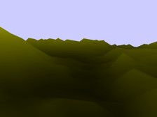 Flyby is an OpenGL-based 3D terrain simulator. It reads data from topographic maps of the earth, then displays it in a 3-D window, with camera controls including pitch, yaw, and movement. Includes ability to dynamically change landscape height factor.
Projects
Fact: Regular expressions just might save the world someday.
 Updates via Twitter
- Sun, Feb. 12 @ 8:50 PM PST:
My corner store just said they don't stock ice because it's winter. WTF? - Wed, May. 2 @ 7:07 AM PST:
A new single from The Suckers: "Mayday". Download it here: http://t.co/nS1Ig3iY - Tue, Aug. 14 @ 1:01 AM PST:
Did Dick Sargent ever work with Dick Armey? - Tue, Aug. 14 @ 1:01 AM PST:
Did Dick Sargent ever work with Dick Armey? - Mon, Aug. 27 @ 4:34 PM PST:
Stuck at Dexter and Mercer for 10 minutes. But hey, the Mercer Mess is fixed, right?

© 2026 Dave Short.
Released under a Creative Commons license.
Valid XHTML and CSS.